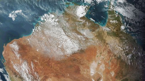
As the first really intense heat of the spring baked Western Australia this week, with Perth breaking the record for its hottest September day, a remarkable weather phenomenon unfolded in the skies above the state.
In northern WA and the western and central parts of the Northern Territory, thousands of cumulus clouds formed in the sky, creating a pattern that looked a little like a traditional Aboriginal dot painting.
Why was this remarkable?

Because the clouds had a very unusual source of moisture, that's why.
Cumulus clouds are the puffy "cotton wool" clouds with which we are all familiar, and they require heat and moisture to form.
Heat in that part of Australia is a given at this time of year, but moisture is usually lacking in a region that includes parts of both the Gibson and Great Sandy Deserts.

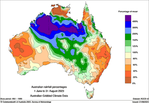
But as the large dark blue and purple blobs in the BoM chart above show, 2023 winter rainfall was way above the long-term average in the areas where the cumulus cloud "dots" formed this week.
All that extra rain made lush grass grow in areas where the ground cover is usually dusty or stony when the springtime heat arrives, and this week's clouds dots drew their moisture from the unseasonably lush vegetation.
That's right, cloud can actually also form by drawing moisture from vegetation (under the right conditions) through a process known as "evapotranspiration".
The downside of all that vegetation is an increased fire risk in many parts of northern Australia this coming summer, at a time of year when the focus tends to be on the fire risk further south.


