Your web browser is no longer supported. To improve your experience update it here
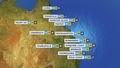
Australian synoptic weather chart
National Synoptic
View national weather
Thursday 12:10 EST
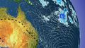
A high will cause brisk winds and showers to ease in SA, TAS and VIC. Strong southerly winds and a trough will causes showers and storms over eastern NSW and southeast QLD. Another trough will trigger the odd storm for inland/north WA, while drawing heat in the north.
Issued Wednesday 22:10 EST

Friday 12:10 EST
A trough in the east will bring gusty winds, showers and large waves to eastern NSW and southeast QLD. A broad trough will maintain heat across the north and interior, while triggering showers and storms in WA's north. A high will keep elsewhere generally dry and cool.
Issued Wednesday 22:10 EST

Saturday 12:10 EST
A trough and front will bring gusty showers to TAS. Warmth will be drawn ahead of the trough into VIC and western NSW. A broad trough drawing heat into the north will cause storms over WA's interior. High pressure building over the east will clear showers and ease winds.
Issued Wednesday 22:10 EST

Sunday 12:10 EST
A trough will draw warmth into the SA, VIC and TAS. A cold front and trough should cause a few showers and bring brisk winds to southern WA and western SA. A trough extending over the north will draw heat and drive a few storms. Settled and dry in the east with a high pressure.
Issued Wednesday 22:10 EST

Monday 12:10 EST
A trough and cold front will bring showers and some storms to TAS, VIC and southern NSW, while drawing heat into the east. A broad trough extending over the north will draw heat and drive a few showery thunderstorms. High pressure will keep the south mostly dry and settled.
Issued Wednesday 22:10 EST

Tuesday 12:10 EST
A trough should bring cool winds and a few showers to TAS and VIC. Heat will be drawn into QLD and the north with low pressure troughs, with a cool wind change moving over eastern NSW. The trough should bring some thundery showers to the Top End. Settled elsewhere with highs.
Issued Wednesday 22:10 EST
Weather Articles
Data supplied byWeather Zone